Çanakkale isn’t just a dot on the map. It’s a choke point. For centuries, empires fought over this strip of land where the Aegean Sea meets the Dardanelles. It hosted everyone from the Trojans to the Ottomans. But its modern fame? That comes from two very different stories. One is a wooden horse made of myth. The other is a graveyard of mud and blood from World War I.
Today, the city has about 542,000 people. Tourists flood in from Turkey and all over the world. They come for the ghosts. They come to understand how a small province became a global symbol of resistance and tragedy. If you’re planning a trip, you need to look past the souvenir shops. You need to understand the layers.
The Myth You Can’t Ignore
Let’s start with the elephant in the room. Or rather, the horse.
The Trojan War is legendary. The Trojan Horse is its most famous artifact. Archaeologists have dug up Troy (Troya) nearby. You can walk the same ground where Homer’s epic supposedly unfolded. The ruins are impressive. The walls are high. The museum in the town center holds artifacts that date back thousands of years.
But here’s the thing. You can’t just visit the ruins and leave. You have to feel the scale. The acropolis sits on a hill. The view of the strait below is staggering. It makes sense why armies wanted this spot. Control Çanakkale, control the sea.
The Blood in the Soil
Then there’s the Great War. 1915.
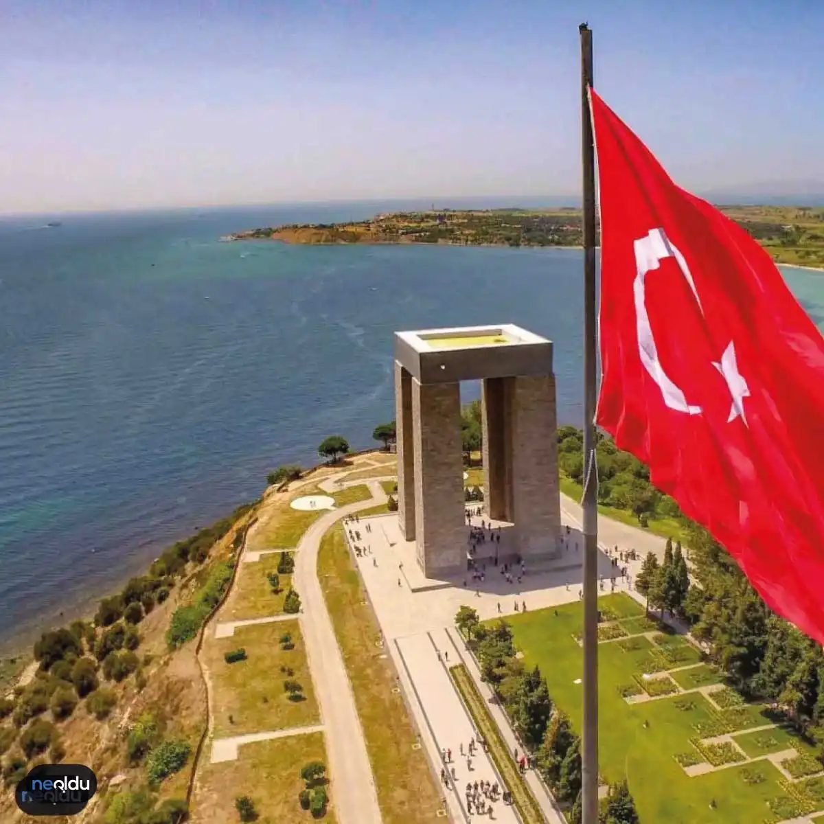
This wasn’t just a battle. It was a meat grinder. The Gallipoli Campaign (Çanakkale Savaşı) involved forces from Australia, New Zealand, Britain, and France against the Ottoman Empire. The casualty rates were horrific. The terrain? A nightmare of steep cliffs and narrow beaches.
For Turkey, this war is foundational. It birthed the modern republic. Mustafa Kemal Atatürk rose to fame here. He was a division commander who rallied troops on these shores.
If you visit, go to the Anzac Cove (Anzak Köyü). Go to Conkbayırı. These aren’t just names. They are shrines. The cemeteries are meticulously maintained. The headstones are uniform. They stretch up the hillsides. It’s quiet. It’s heavy.
Why It Matters Now
Çanakkale is a case study in how history shapes tourism. People don’t just want sun and sea here. They want meaning. They want to connect with the past.
The region offers a unique blend. You can hike through ancient ruins in the morning. You can stand on a battlefield at noon. You can drink tea overlooking the strait in the evening. It’s a jarring transition. But it’s real.
Planning Your Trip
So, how do you approach this?
- Timing matters. Spring and autumn are best. Summer is hot and crowded. The light is softer in April or October.
- Logistics. You’ll likely fly into Çanakkale Airport or Istanbul. From there, it’s a few hours’ drive.
Why Çanakkale’s History Matters to Your Itinerary
You aren’t just visiting a province. You’re walking through layers of human survival. Settlement evidence here goes back to 3000 BC. Some ruins, like those in Ayvacık’s Coşkuntepe or the Karaağaçtepe site on the Gallipoli Peninsula, date back even further to 6000 BC. These weren’t passive observers. They herded livestock. They fished. They built the first permanent communities in the region.
The Bronze Age hit hard here. Troy didn’t just sit there; it fortified. With walls over five meters high, this was one of the strongest settlements of the era. Ten distinct layers of habitation sit beneath the soil near the Marmara and Black Sea connection. Writing itself appeared in Troy around 1200 BC. That’s when you see the first records of the complex social shifts that followed.
The Layers of Conquest: From Troy to Rome
History here moves fast. After the Trojan War, Achaeans arrived. Then came Aegean migrations. By 750 BC, Greeks were establishing colonies across the landscape. Power shifted again to Lydia in the 7th century, then Persia by the 6th.
Xerxes built the first bridge between Asia and Europe here. It’s a logistical marvel that still defines the geography. Alexander the Great took control in 334 BC. Rome followed in 133 BC. The region was always a choke point. Always a prize.
How Turkish Influence Changed the Region
The Seljuk Empire’s collapse in the 14th century created a vacuum. Turkish groups moved into the Aegean area. Çaka Bey pushed Turkish military strength as far as Nara Burnu in 1095. But the real turning point came in 1354.
Süleyman Pasha captured Gelibolu Fortress. That moment secured Turkish dominance over the entire Dardanelles Strait. The geography remained critical, but the political map changed forever.
The Great War and the Birth of Modern Türkiye
This part of the story isn’t just military history. It’s national identity. During the late Ottoman period, Çanakkale became the stage for a desperate defense. Allied forces—British, French, Russian—launched a naval and land assault starting in 1914. The campaign lasted two years.
The result was decisive. The Turkish forces held the line. They proved the straits were impassable to invasion. This victory paved the way for the Republic of Türkiye. Çanakkale became a province. It remains a symbol of resilience.
Navigating Çanakkale’s Climate for Your Trip
When do you go? The weather here dictates your experience. Summers get hot. Dry. Coastal humidity can make July and August feel heavier than the thermometer suggests. If you want to hike the Troy ruins or walk the Gallipoli battlefields without collapsing, spring or autumn is better.
April through June offers mild temperatures. Rain is possible, but usually brief. September and October are similar. The heat breaks, but the sun is still strong. Winters are cool. Rainy. The Gökçeada island can be windy. If you’re planning a ferry crossing, check the wind forecast. The Dardanelles can get rough.
Pack layers. Even in summer, evenings cool down near the water. In spring, bring a rain jacket. The microclimates vary between the peninsula, the mainland towns, and the islands. What feels like a sunny day in Çanakkale city might be drizzling on the slopes of Mount
Weather and Terrain: What to Expect on the Ground
Forget the idea that Çanakkale is purely a Mediterranean hotspot. Geographically, it sits in a transitional zone, meaning the weather here has a mind of its own. You get Mediterranean warmth, sure, but because it pushes further north than places like Antalya or Izmir, the winters bite. The average annual temperature hovers around 14.7°C—a number that feels much lower when the wind is howling off the Dardanelles.
Wind is a character here, not just background noise. You’ll feel Poyraz (the north wind), Lodos (the humid southwest), Yıldız, and Kıble. These aren’t just names on a weather app; they dictate how you pack. If you visit between December and February, brace for the bulk of the yearly rainfall, which totals roughly 854.9 mm. Snow is rare—about eight days a year on average—but the damp cold seeps into your bones.
The landscape itself is a mix of rugged nature and cultivated land. Over half the province is forested. It’s not just trees; it’s a specific palette of maki, laurel, myrtle, and thick shrubbery lining the hills. Deeper in the woods, you’ll spot red pine, black pine, oak, beech, and fir. The inland valleys? That’s where the grain grows, sheltered from the coastal gusts.
Why Çanakkale’s Geography Matters for Your Trip
Understanding the terrain helps you plan better. The fertile soil isn’t just for show. It’s why the local economy leans heavily into agriculture. If you’re driving through the hinterlands, you’re passing through some of the most productive farmland in Turkey. You’ll see barley, wheat, sesame, and tobacco fields stretching out. But it’s the fruits that steal the show.
Local orchards are famous for their yield. We’re talking about peaches, pears, cherries, and apricots that taste different here—sharper, more intense. Grapes thrive in the specific microclimates created by the coastal mountains. This isn’t just tourism marketing; it’s an agricultural reality.
Livestock is woven into the landscape too. Sheep, goats, and cattle graze on the meadows that aren’t under cultivation. Beekeeping is surprisingly common, adding a sweet layer to the rural economy. And then there’s the sea. Fishing isn’t just a hobby; it’s a primary livelihood. The Dardanelles and the Aegean coast provide a steady catch, making seafood a staple on menus far beyond the tourist traps.
Planning Around the Seasons
When should you go? If you want to hike the olive groves and walk the beaches without fighting the heat, spring and early autumn are your best bets. The rain has stopped, but the air hasn’t dried out completely. Winter is for the brave, or for those looking for empty ruins and quiet cafes. Summer brings the heat and the crowds, but also the best conditions for swimming in the Aegean waters.
Pack layers. Even in summer, the evening breeze off the water can chill you. A light jacket is smarter than a heavy coat. And if you’re driving inland toward the grain fields or the pine forests, watch out for sudden fog patches, especially in the morning. They roll in fast
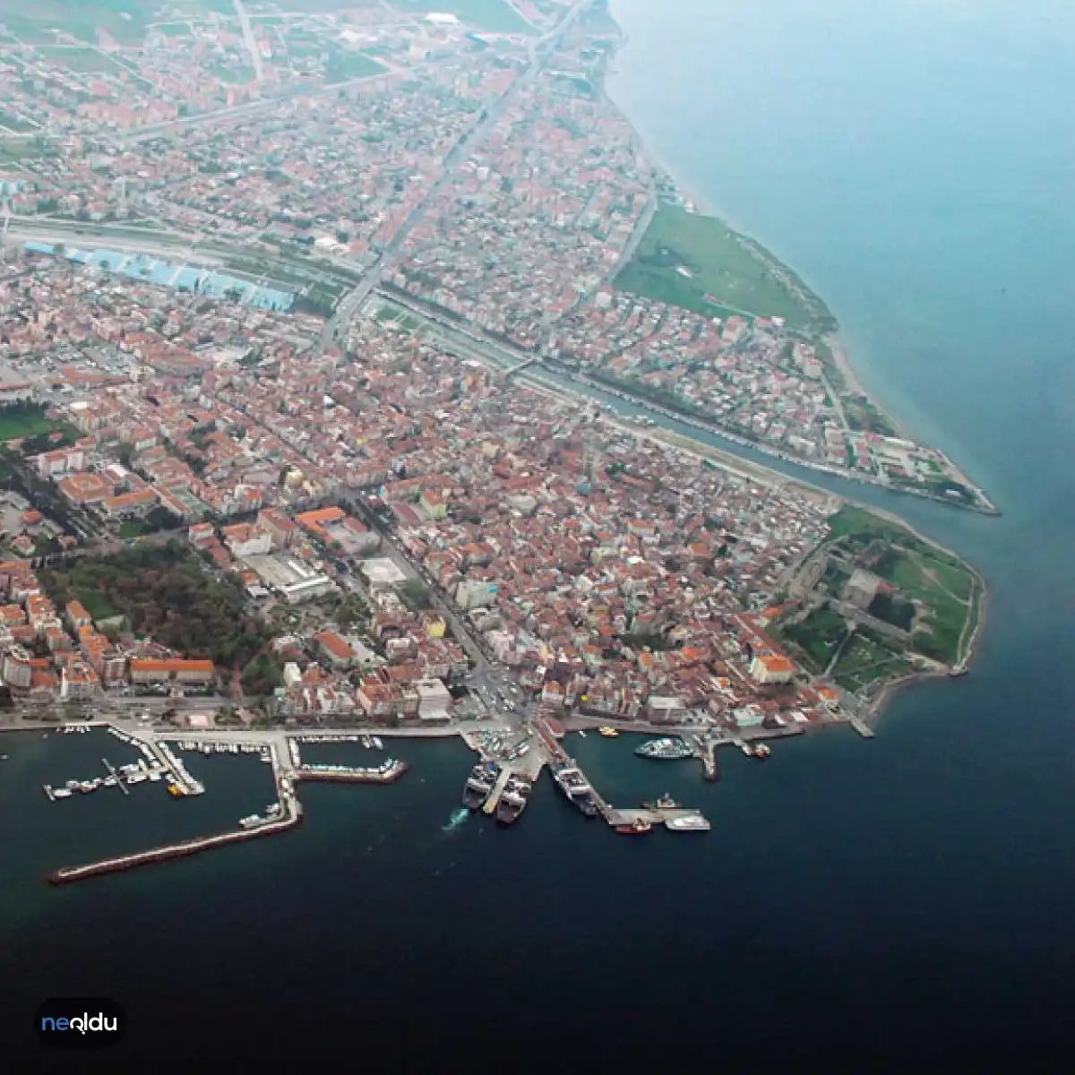
Çanakkale, haritada iki kıtanın kesiştiği o hassas noktada duruyor. Avrupa ile Asya arasında, tarih ve doğanın iç içe geçtiği bir şehir. Edirne, Tekirdağ ve Balıkesir ile komşu. Yüzölçümü 9.933 kilometrekare. Coğrafi sınırları biraz karmaşık, ama mantıklı. Büyük kısmı Marmara Bölgesi’nde. Edremit Körfezi’ne bakan kısmı ise Ege’ye ait. Bu ayrım, iklimi ve mutfağı da değiştiriyor.
Dağlık bir yapıda. En yüksek noktası Kaz Dağları. 1.767 metre. Ege’nin en yüksek dağı olarak da biliniyor. Buradan inen su kaynakları, bölgenin zengin bitki örtüsünü besliyor. Şehir, Türkiye’deki deniz balıklarının üçte birine ev sahipliği yapıyor. Bu istatistik, mutfak kültürünü ne kadar zenginleştirdiğini gösteriyor.
Deniz, Ada ve En Batı Noktası
Çanakkale’nin kıyı şeridi 671 kilometre. Sadece karaya bağlı olmayan bir şehir. Büyük adaları var: Bozcaada ve Gökçeada. Türkiye’nin en büyük ikinci adası Gökçeada. En batı noktası burası. Ege’nin mavi sularında, farklı bir zaman diliminde yaşayabilirsiniz.
Adalara gitmek için feribot alternatifi. Çanakkale merkezden veya Gelibolu’ndan başlayan seferler, günlük değişen frekansta. Yaz aylarında kalabalık olur. Hafta içi daha sakin. Bilet fiyatları mevsime göre değişir. Erken rezervasyon, özellikle Gökçeada için önemli. Ada içi ulaşım araba veya bisikletle daha keyifli. Otobüs seferleri sınırlı.
Gelibolu Yarımadası: Tarihin Izları
Çanakkale denince akla gelen ilk yerlerden biri Gelibolu. 1915 Çanakkale Savaşları’nın geçtiği zemin. Burada yürüyüş yapmak, sadece tarih okumaktan farklı. Toprak kokusu, deniz rüzgarı ve sessizlik… Anzac Cove, Lone Pine, Suvla Bay. Her köşe, bir hikaye anlatıyor.
Ziyaret için en iyi dönem Nisan-Ekim arası. Kış ayları rüzgarlı ve soğuk. Yazın ise sıcak ve kalabalık. Müze girişleri uygun fiyatlı. Bazı alanlar ücretsiz. Rehberli turlar, detayları daha iyi anlamak için faydalı. Kendi başınıza gezmek de mümkün. Yol işaretleri genellikle açık.
Bozcaada: Şarap, Sanat ve Sakinlik
Bozcaada, daha küçük. Daha intime. Şarapları meşhur. Ege’nin tuzlu rüzgarı,
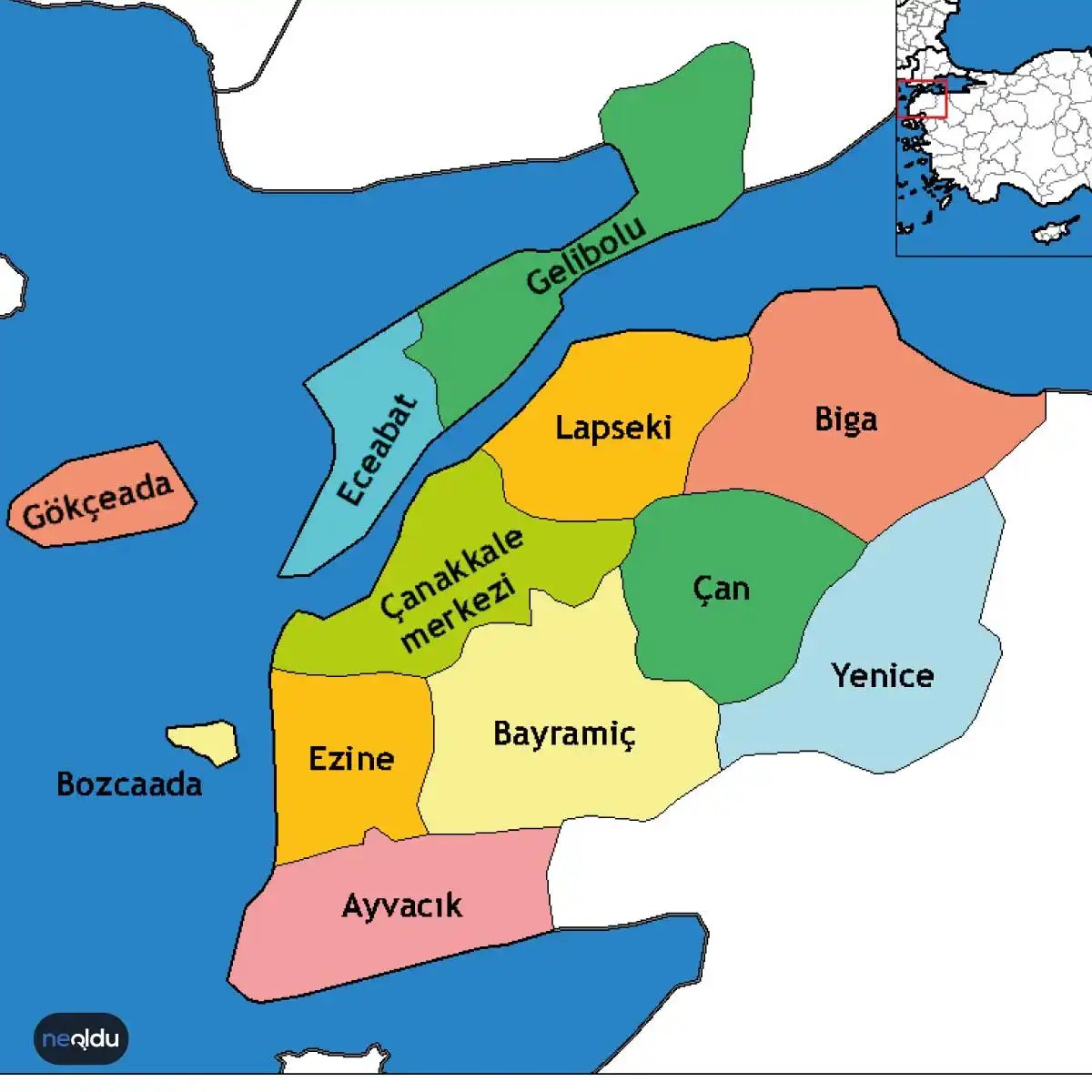
Çanakkale, Ege ile Marmara’nın kesiştiği, tarihle denizin iç içe geçtiği, tam anlamıyla bir geçiş noktası. Ama bu geçişlik sadece coğrafi değil, kültürel ve hatta turistik bir karmaşa da yaratıyor. Ziyaretçiler genellikle sadece Gelibolu Yarımadası’nı veya Troia’yu aklına getiriyor. Oysa il, kendi içinde on bir farklı dünyaya ev sahipliği yapıyor. Her ilçenin kendi havası, kendi tarihi katmanları ve kendi “gitmeden olmaz” listesi var.
Çanakkale’nin 11 İlçesi: Nereye Gideceğinize Karar Verin
İlçeleri saymak kolay. Seçmek zor. İşte Çanakkale’yi oluşturan on bir parça ve onlara dair kısa, net tespitler. Bu liste, rotanızı çizerken size bir pusula görevi görecek.
- Ayvacık : Genellikle pas geçilir ama yanlıştır. Semavri Kervansarayı buradadır. Osmanlı mimarisinin sade ama güçlü örneklerinden biri. Sessizlik arıyorsanız, burası tam size göre.
- Bayramiç : Daha çok tarım ve zeytinle bilinir. Ancak yöresel lezzetleri ve sakin kasaba dokusu, özellikle uzun hafta sonları için iyi bir durak.
- Biga : İlçe merkezlerinden biri. Tarihseverler için Elenist dönemine ait kalıntılar, özellikle Antandros yakınında dikkat çekiyor. Yeşilin her tonunu barındıran bir alan.
- Bozcaada : Akdeniz’in İtalya’sı denilirse, bozulmuş bir benzetme olur. Doğrusu: Bozcaada, Bozcaada’dır. Şarap evleri, sanat sokağı (Alaçatı’nın daha yumuşak, daha yavaş versiyonu) ve gün batımı. Yaz ortası kalabalığını atlatmayı başarabilirseniz, yılın en güzel zamanı.
- Çan : Zeytinin kralı. Çan zeytini, Türkiye’deki en değerli markalardan biri. İnce yapılı, tarihi dokusu korunan bir ilçe. Turistik değil, yerel.
- Eceabat : Troia’nın kapısı. Çanakkale Savaşları’nın en yoğun anı burada yaşandı. Anzak Koyu, Conkbayırı, Seddülbahir… Buraya gelip sadece Troia’ya bakıp dönmek, Paris’e gidip Louvre’dan çıkmak gibi bir şey. Mümkünse yerel rehberle gezmeyi düşünün.
- Ezine : Zeytinin kralı dedik ya ya, Ezine de zeytinin prensi. Çan zeytiniyle yarışır. Ama Ezine’yi özel yapan
Getting to 17: The Logistics of Reaching Çanakkale
The license plate is 17. If you’re dialing a landline from outside the city, you need the 0286 area code. But numbers on a plate or a keypad don’t get you there. Getting to Çanakkale requires a bit more effort than just picking a destination on a map. It’s a gateway city, physically straddling the Dardanelles, and that geography dictates every mode of transport.
By Air: The Fastest Route
Most travelers don’t fly directly into Çanakkale Airport (CKZ) unless they are booking a specific charter or private flight. Commercial service to CKZ is sporadic, often limited to domestic routes from Istanbul or seasonal European flights. It’s cheaper, sure. But it’s also less reliable.
The standard route is flying into Istanbul (IST or SAW) or Ankara. From Istanbul, you’re looking at a 1.5-hour flight to Çanakkale, or a longer, more scenic drive. If you land in Istanbul, don’t just head to the airport exit. The traffic can be brutal. Take the Havaist shuttle to the city center, then transition to the bus network.
By Sea: The Ferry Experience
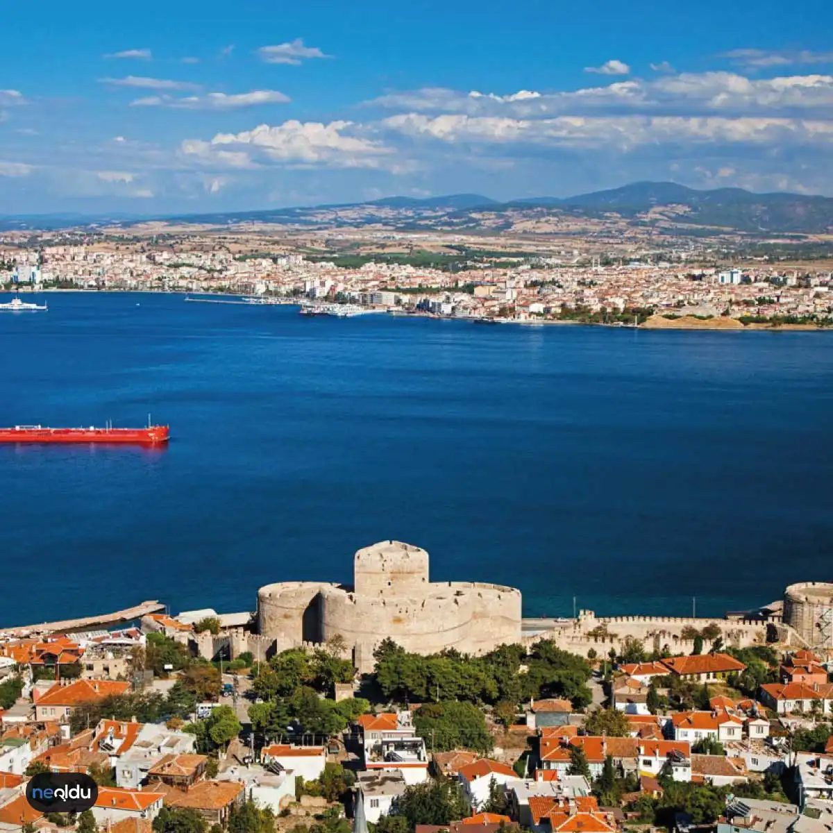
This is where the trip gets interesting. Çanakkale is a port city. The Dardanelles (Çanakkale Boğazı) are not just water; they are a historical choke point. If you’re coming from the Aegean coast (like Ayvalık or Dikili), you might hop on a ferry. These aren’t luxury liners. They’re workhorses. The crossing takes about 45 minutes to an hour. It’s cheap—often under 100 TL for a foot passenger, maybe a bit more if you take your car. The wind kicks up. The waves get choppy. You’ll see the Gallipoli peninsulas looming in the mist.
If you’re coming from the Asian side of Istanbul, you can take a ferry to Gebze or Yalova, then drive or take a bus. But why bother? The direct bus is usually more efficient unless you’re bringing a RV.
By Road: The Bus Network
Turkey’s intercity bus system is robust. Companies like Metro, Kamil Koç, and Pamukkale Turizm run frequent services from major hubs.
- From Istanbul: The drive takes about 3.5 to 4 hours. It’s a straight shot west on the O-5 highway, crossing the second Bosphorus bridge (Yavuz Sultan Selim). The tolls add up. You’ll pass through Tekirdağ and Edirne provinces. The landscape flattens out into the Thrace plain before hitting the coastal roads.
- From Izmir: Roughly 3.5 hours. You’ll drive north along the Aegean coast, then cut inland. The road is generally good, though traffic near the city center can be congested.
- From Ankara: About 5 hours. The route goes through Eskişehir and Bilecik. It’s a long haul. If you’re tired, break it up in Eskişehir for dinner.